|


The Adventure Begins
On the Mississippi
Canoeing the Missouri
End of the Trail
(Video Help)

Read about the Corps of Discovery
Find out more about the Lewis and Clark Trail
|
|
Following the Perilous Journey of Lewis and Clark
 We picked this dispatch as today's "Best." We picked this dispatch as today's "Best."
Click here to have future picks e-mailed to you!
The word came from on high: "You are to find your way to the Pacific Ocean." These were President Thomas Jefferson's orders to Meriweather Lewis in 1800. They were also my orders from Jeff, head honcho at the Odyssey almost 200 years later. Just as Lewis had set off with his trusty partner, William Clark, to find a water route to the Pacific, my trusty partner Irene and I were headed out West to follow along the same trail. Just as Lewis had written in his journal, I too, would be keeping track of our journey. And c'mon... Jeff...Jefferson...an uncanny similarity, don't you think? Well, that's about where the similarities end. We did have some great adventures though...check out my journal entries to find out more!
October 10, 2000
The first day of our journey.
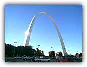
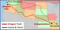
We started this morning in St. Louis, Missouri, the self-proclaimed "Gateway to the West." Not far from here was Camp Wood, where the Lewis and Clark expedition assembled before beginning their trek.
I have decided to assume the role of Captain Meriwether Lewis. Lewis was a personal friend as well as private secretary of President Jefferson's. He was quiet, serious and intense. Me...quiet and serious?? Not so much. But I figure, with a name like Meriwether, how could I go wrong?
The real Meriwether had many preparations to make for his long journey. He took crash courses in medicine, botany and zoology. He studied maps and journals of fur traders and trappers who had been up the Missouri River. He basically tried to learn everything he needed to know for his journey out West. With road maps and Internet access galore, my preparations are a bit less complicated.
Jefferson wanted Lewis to find a water route to the Pacific Ocean. In 1803 the United States had acquired a huge amount of land from France in what is called the Louisiana Purchase. At less than 3 cents an acre, it was a great deal -- $15 million for 828,000 square miles! -- that doubled the size of the country. Jefferson wanted to learn more about the lands west of the Mississippi River, including the different plant and animal species that were out there.
Lewis selected William Clark, his ex-commanding army officer, to be his co-captain for the expedition. Clark was the more outgoing one, an expert watersman and mapmaker. I let Irene know that these will be her duties on our trip. Instead of preparing for the country's future like Lewis and Clark, the two of us are out on an adventure to discover its past.
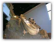
And what about gear for the journey? Good ol' Lewis and Clark had tons and tons of equipment, food and trade goods piled up in their keelboat and two canoes. It was enough to fill 3 moving vans.
We are traveling with enough supplies to fill one dark blue Toyota Tercel named Turkey. We have our tent and sleeping bags and are stocked with food, everything from mac 'n cheese to carrot sticks -- true frontiersmen's diet.
Lewis and Clark also had a group of about 30 men called the Corps of Discovery -- soldiers, frontiersmen, boatmen and Clark's slave York.
Irene and I just have each other, but hey, that's all we need.
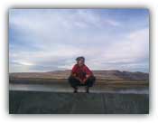
Tonight we are camping out in Independence, MO. I am anxious for our journey to continue. It seems funny that we are searching for the Pacific Ocean when we both grew up right next to it.
October 13, 2000
We're in Billings, Montana right now. Days and states seem to blend together and we're definitely moving at a different pace than Lewis and Clark. We've cheated a bit and strayed from their original trail, which took them up the Missouri River into South and North Dakota. It was in North Dakota that the Corps built Fort Mandan and spent the winter.
An invaluable addition was made when they hired a French guy named Toussaint Charbonneau and his Shosone wife, Sacagawea as interpreters.
Now that we were back on track, we want to be as authentic as we possibly can and decide to camp out in the great Montana outdoors. The two-lane road to the campgrounds is dark and windy and while Lewis was keen on finding animals, I am terrified of hitting one with our car. We stop twice to ask where we can camp and get the same reaction both times. "Camping?! Where are you from?!"
Not a promising sign, but we continue on. After all, Lewis and Clark would keep going. We finally find a place to camp near a creek. I stop the car. It is late into the night and deep into the backcountry. The area is deserted. After making a Blair Witch comment under her breath, Irene says, "It is Friday the 13th by the way." We exchange wary glances. Forget authenticity. I start the car and we head back toward town to stay at an actual established campground -- one with bathrooms and lights and other people around. Hey, if we had a whole Corps of Discovery with us, I'm sure we could have conquered anything... but with just the two of us, it was definitely a bit spooky!
October 14, 2000
We woke up in the morning to much frost on the ground and on our tent. It was going to be a cold day out on the river -- where we were planning on spending the day. A few hours and many layers of clothing later, I was toasty warm and ready to tackle the wild and scenic waters.
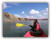
The Lewis and Clark Canoe Expeditions provide the canoes while Irene and I use our bulging muscles to provide the power. It is roughly a 4-hour, 18-mile journey to Fort Benton. Being on the water is beautiful and relaxing. Yet at the same time, we start thanking our lucky stars that we only have to pretend to be Lewis and Clark for a short time. We (or rather our arms) can't imagine months and months of this canoeing thing. Especially when we think of all the times the Corps had to go against the current or carry their boats around the rapids or deal with unfavorable weather conditions, troublesome mosquitoes and sickness.
October 15, 2000
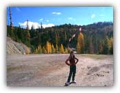
After spending the night in Missoula, MT, we are ready to continue our travels into Idaho. It is another beautiful day and we are excited to be traveling on the Lolo Trail in between the Bitterroot Mountains that divide Montana and Idaho. The trail is a welcome change in scenery from the miles and miles of brown fields that we have gotten used to on this trip. The mountains are covered in green-, and red-, and yellow- frosted trees. I'm sure these colors would have been a welcome change for Lewis and Clark since they saw this area covered in white... snow and ice, which gave them their most treacherous winter. Luckily, they were given horses and guides by a Shosone chief named Cameahwait...who turned out to be Sacagawea's brother!
By late afternoon we reach the meeting of the Snake and Clearwater rivers where the towns of Lewiston, Idaho and Clarkston, Washington have been named after the co-commanders.
October 16, 2000
The drive today is fabulous. We are traveling along the Columbia River in Oregon and the scenery is breathtaking. We stop at the Horsetail and Multonomah Falls to enjoy even more natural beauty. We are getting antsy to see the Pacific.
October 17, 2000
Lewis and Clark traveled 4,142 miles over 18 months of swollen rivers and treacherous mountains to make it to the Pacific. They identified 178 new plants and 122 species or subspecies of animals and encountered about 50 Native American groups.
Neda and Irene completed 9 days of highway driving, passing beautiful scenery, a few cities, and some Native American reservations.
October 18, 2000
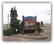
"Ocian in view. O! The joy!" The words of William Clark (he was not the best speller!) sum up our emotions perfectly. We are in Seaside, Oregon at the end of the Lewis and Clark Trail. Despite the fact that I have seen the ocean hundreds of times before, there is a special feeling to it this time.
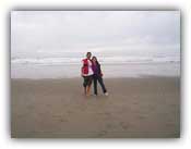
We are so excited that as soon as we get out of the car, we can't help ourselves anymore. We run to the waters, rolling up our pant legs, throwing off our shoes, laughing and yelling our way into the waves. The water is freezing and the weather outside is quite dreary and cold. But nothing was going to stop us from feeling that water crash over our cute little toes. We had made it!
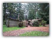
We also stop at Fort Clatsop in Astoria, Oregon where the Corps spent four months waiting out the winter and preparing for their journey all the way back. Irene and I are about to start our own voyage across the country once more to report back to our teammates on the East.
Perhaps we will take a few days to rest, but we are definitely ready for some more adventures!
Neda
Please email me at:
neda@ustrek.org
Links to Other Dispatches
Neda - A Toyota Tercel named Turkey on the trail of Lewis & Clark
Irene - Pack 'em in and move on out West!
Neda - The Donner Party: How far would you go if you were starving?
Kevin - The battle that begat the anthem heard 'round the world
Neda - Steamboating the Mississippi...in a floating McDonald's?
MAD - We speak for the trees, for the trees have no tongues
Irene - Beware of Free Lunches, Especially When It's Offered by the Government
Irene - Extra! Extra! Hunting for Gold Leads to More Misery Than Happiness!
|